Hurricane Dorian made landfall in the Bahamas yesterday as a Category 5 major hurricane, with sustained winds of 185 mph and gusts over 220 mph, making it a “catastrophic” storm with “devastating winds,” according to the National Hurricane Center.
It’s since stalled in the Atlantic Ocean, hovering over The Bahamas at a mere 1 mph while edging closer towards Florida’s east coast, with no sign of turning in sight. The good news is, it’s downgraded to a Category 4 hurricane, but that’s no reason to let your guard down.
In many ways #Dorian is an even worse hurricane today than yesterday. Forward motion 24 hours ago was 7 mph, now essentially zero. A stationary major hurricane over low-lying populations is the worst. Also it’s a bit larger now and high waves extend much farther from center. pic.twitter.com/qAv42ByNSH
— Dr. Rick Knabb (@DrRickKnabb) September 2, 2019
Here are the Key Messages for Hurricane Dorian per today’s 11:00 AM update from the National Weather Service:
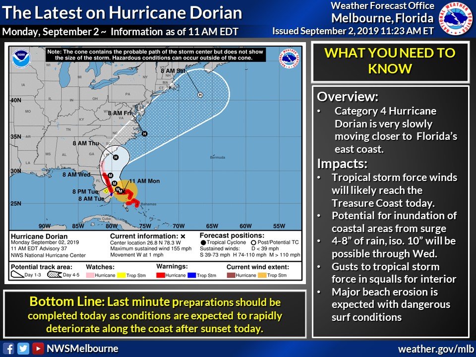
As the current forecast stands, Central Florida will feel impacts on Tuesday and Wednesday, with South Florida potentially seeing impacts as early as this afternoon. (Live update: It’s looking pretty ominous outside.) A Tropical Storm Warning has been issued for the Orlando area as well, however Walt Disney World remains open and operating under normal conditions despite storms:
The weather is changing quickly at Hollywood Studios. pic.twitter.com/UadFS91ULB
— WDW News Today (@WDWNT) September 2, 2019
Per the Orlando Sentinel,
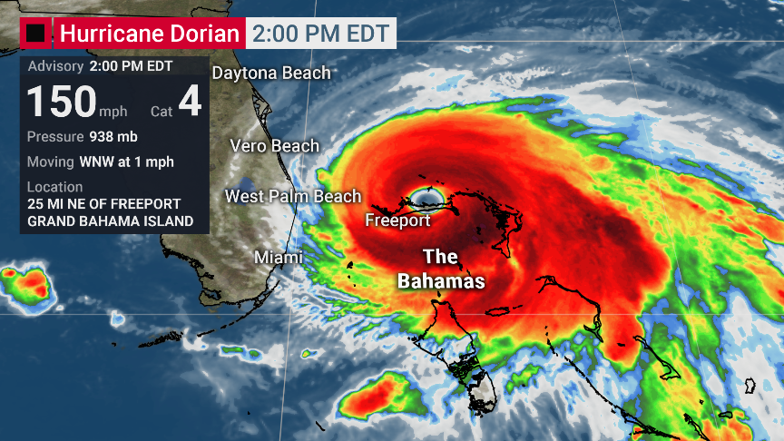
The National Hurricane Center in its 1 p.m. update said Hurricane Dorian’s maximum sustained winds remained at 155 mph, making it a Category 4 hurricane with gusts still up to 190 mph. The storm continues to slog over Grand Bahama Island, about 25 miles east of Freeport, Grand Bahama and about 105 miles east of West Palm Beach, moving west-northwest at 1 mph.
“This has been frustrating, I know, for a lot of people because it seems like we’ve been talking about this a long time, but we are in a situation where the storm is stalling very close to our coast,” said Florida Gov. Ron DeSantis from the state Emergency Operations Center. “It is going to make a move, and the movement that it makes is going to have a lot of impacts on Floridians.”
DeSantis sought to guard against “storm fatigue,” urging residents to pay attention to local alerts and evacuation orders, in case the storm jogs west before turning north, as most forecasters predict.
The Orlando International Airport has stated it would lift its original plans to close on Monday, September 2nd and will be continuing commercial flights until further notice.
You can check for any further updates for Hurricane Dorian from the National Hurricane Center here, and read up on Walt Disney World’s hurricane policy here.
We ask that all of our readers within the cone of uncertainty please have their preparations ready by today, and to keep safe! We will continue to update as further advisories are issued.
Featured Image: The Weather Channel


Here in Colorado, hoping you all stay safe down there in Florida.